Census puts Gypsies and Irish Travellers on the map
An interactive map showing the percentage of Gypsies and Irish Travellers living in England and Wales has been published.
The map is part of the UK Government's 2011 Census website which also includes lots of other data that is used by Govenment departments, local authoities and businesses.
The census – a count of households and people has taken place every ten years since 1801 (apart from 1941, when it didn’t happen because of the war). One of the reasons it is carried out is to help public sector organisations understand what support and services people need. The results are used, for example, to help plan school places, housing, health facilities, public transport and emergency services. The census took place on 27 March 2011, when every household should have received a questionnaire asking for information about the people who live there. Taking part in the census is compulsory.
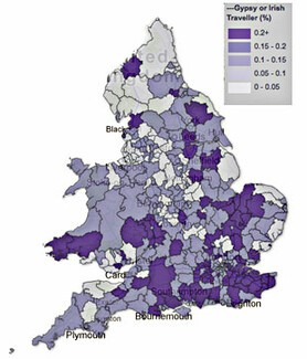
The map shows that percentage of Gypsies and Irish Travellers varies across England and Wales from 0% - 0.05% to 0.2% of the total population (or at least of those people who completed the census).
It is possible to see this variation in each county and region, and you are able to zoom in and search for a specific place or area.
Take a look for yourself at the area that you are currently living in.
You can see the Ethinicity Map by following this link to the Census website
Read these related articles: